"WTF is this a map of?" Challenge
Created on: August 30th, 2006
"WTF is this a map of?"  Challenge
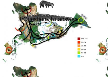
To get this right you have to answer three questions. A) What do the lines indicate? B) What do the numbers mean? C) Why is the map positioned as it is?

Sponsorships:

Vote metrics:

rating total votes favorites comments
(3.08) 12 0 18

View metrics:

today yesterday this week this month all time
0 0 0 0 1,181

Inbound links:

views url
5 http://ytmnsfw.com/users/Huckle/

Add a comment

Please login or register to comment.
August 30th, 2006
(0)
Read description
August 30th, 2006
(0)
Yay. Downvoted already.
August 30th, 2006
(0)
It looks like difficulty and difficulty does not deliver the 'lulz'
August 30th, 2006
(0)
Routes of ancient human settlement based on the out-of-Africa theory?
August 30th, 2006
(0)
3'd thats trippy.... it looks like some kind of route. i have no idea
August 30th, 2006
(0)
that's all the continents before they were divided
August 30th, 2006
(0)
the lines show the direction the continents are moving in
August 30th, 2006
(0)
Answer the following to get full credit:
August 30th, 2006
(0)
What do the lines indicate? What do the numbers mean? and finally, why is the map positioned as it is?
August 30th, 2006
(0)
The EARTH!!! I win. Now gimme a cookie.
August 30th, 2006
(0)
The continents before they separated...you just don't have it "circular" you have it sprawled out on one page..the arrows indicate the path of the "separations" gg I win give me a steak or something.
August 30th, 2006
(0)
The numbers mean elevation.
August 30th, 2006
(0)
So far everyone is wrong or incomplete in their answers. Keep trying.
August 30th, 2006
(0)
A. The lines indicate the path of Human migration. B. The numbers are how many thousands of years ago. C. So none of the lines are broken by the edge of the map.
August 30th, 2006
(0)
Rocketman has the idea, but his answer to C) isn't what I'm looking for. It's much more basic and simpler than that.
September 1st, 2006
(0)
C) is it's centered around the north pole.
September 25th, 2006
(0)
I'd say for C), it's the best way to depict the distances of the migrations in an authentic way. Naval(oceanic) migration didn't exist(as far as we know today), so the ocean's stretch can be omitted.
December 6th, 2006
(0)
im sorry, but u r gay